The debris flow of Le Pissot
On 13 August 1995, an exceptional local storm with intense precipitation induced a debris flow (50,000 m3) that obstructed the highway N9 near Villeneuve (Figs. 1 and 2). Vineyard (19,000 m2), and around 10 cars were buried under the debris flow. No important injuries were reported.
This debris flow originates from a small steep catchment area. It belongs to the first high relief of the Alps receiving disturbances coming from westward often from the ocean. Every 10-15 years a debris flow of around 4000 m3 occurred in Le Pissot.
The small steep catchment area was built in a steep slope in Mesozoic carbonate series belonging to a tectonized zone created by a fold situated at the top of the slope.
28 Mio Swiss francs were dedicated to defensive measures (channel, basins and debris barrier).
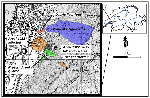
Fig. 1: Situation of the Pissot debris flow and the Arvel Rockfall (From Swiss map 50).
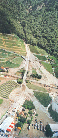
Fig. 2: Picture of the debris flow (from Français O. & Duvernay B., 1997 in Chantiers)
References:
Français O. & Duvernay B. (1997) : Laves torrentielles au Nant-du-Pissot, Villeneuve (VD). L’événement et le concept de réaménagement du site. Chantiers, 26,8, 43-51.
Français O. & Lateltin, O. (1998) : Les laves torrentielles de Villeneuve du 13/14 août 1995. Bulletin Géol. Appl. vol.3, no 1, juillet 1998, pp. 29-36.
Le DSE au quotidien No 6, décembre 2001
Bédat Ch., Alain Oulevey A., Bollaert E. (1997): Ecrêteur 456 du Pissot. Modélisation de laves torrentielles granulaires et boueuses (1996-1998)