The Boup Landslide
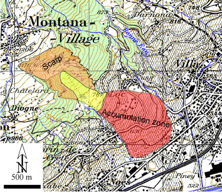
Fig. 1: Approximate zones of the Boub landslides (topographic background from Swiss map 50).
The Boup landslide can be seen on the left at the entrance of Sierre coming from Sion, it is located below the village of Crans-Montana (Fig. 1). The landslide is developed in the helvetic nappe of the Wildhorn. The rocks are principally Triassic dolomite, sandstone, shales and gypsum. Somme lower Jurassic shales (Bruno and Marillier, 2000).
The landslide presents very well developed zones of depletion and of accumulations. In some places the velocities ranges from 10-50 cm/years.
It is also interesting to find the regulation of the commune of Sierre about the construction in the Boup zone (REGLEMENT COMMUNAL DES CONSTRUCTIONS ET DES ZONES de la ville de Sierre, page 49 et 55)
References:
Bruno, F. (2002) : Application de la sismique réflexion et autres méthodes géophysiques à l’étude de versants instables dans les Alpes suisses. PhD Thesis, Univ. Lausanne. 152 pp.
Bruno F., Marillier F. (2000): Test Of High-Resolution Seismic Reflection And Other Geophysical Techniques On The Boup Landslide In The Swiss Alps. Survey in Geoph., 21. 333-248.