Landslide of La Cornalle – Les Luges
This landslide (10 kilometers eastward Lausanne) has been active for 10’000 years since the last ice age with several different crises (Figs. 1 and 2). It is located in upper fresh water molasse. It can be divided in three parts. (1) A supply zone constituted of rock face (link to picture) of molasses sagging on the upper part of the landslides itself (Fig. 3). (2) The upper part (La Cornalle) is a zone of accumulation corresponding to a slow debris slide moving toward southeast on a dip slope, which supplies the landslide channel (3) leading to the lake of Geneva. The channel location is controled by a vertical fault and by the slope direction, it is mainly situated in moraine.
The present movements are small but their effect can be seen in the deformation of the road near the lake.
The first record of activity in the archives dated from approximately 1725. The last crisis dated from 1950, at that time a soil mass reached the railway after a travel of 20 m. The velocity reached in some place 3.2 m/day. Since 1960 the drainage work have been sufficient to stabilize the landslide for large movements and prevent against reactivation from intense precipitation. With climate changes, i.e. greater variability and more intense precipitations, such a landslide can be easily reactivated.
Note that in 1810 an engineer already recommended to drain the surface water and groundwater.
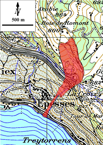
Fig. 1 : Location of the landslide (Topography from MAP50, Swisstopo)
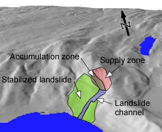
Fig. 2: View of the morphology of the area of the landslide indicating that the whole area is or was affected by slope movements. (3D view from Atlas of Switzerland, Swisstopo).
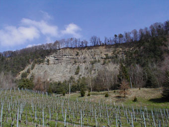
Fig. 3:View of the supply zone scar and the accumulation zone.
References:
Bersier, A. Blanc, P. and Weidman, M. (1975) : Le glissement de terrain de la Cornalle-Les luges (Epesse, Vaud, Suisse). Bull. Soc. Voud. Sci. Nat., 347, 165-191.
Parriaux, A., (1998): Glissement de la Cornalle. Bulletin Géol. Appl. vol.3, no 1, juillet 1998, pp. 49-56.