The Peilletes Landslide
The Peillettes landslide is a complex landslide (Vulliet, 2001). It can be subdivided in several different zones. The landslide is located in the inverse flank of the nappe of Siviez-Mischabel (peninnic Alps). The upper part is situated in the Permian schist and the lower part in Triassic quartzite. It reaches 1 km in width and 2 km in length (Fig. 1). The summit scarp altitude is approximately 2000 m. The preexisting fracturing has favored the sliding, desegregation, weathering and groundwater effect.
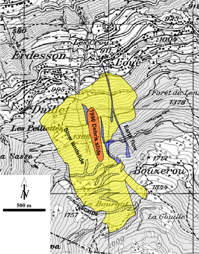
Fig. 1: Map of the landslide (modified after Duti, 1984 ; topographic background from Swiss map 50).
This landslide is very sensitive to the groundwater levels controlled by the snow accumulations above the landslide. Two aquifers control the landslide movements (Bianchetti et al., 2001).
In the central part of the landslide, a debris slide is more active (800 x 150 m) (Fig. 2). Its velocity has reached 35 m/years between the years 1978 and 1983 (DUTI, 1983). It is the most spectacular part of the landslides that can be viewed from the Rhone valley.
Because it is very sensitive to water, many works of drainage are made. However, since the 1980’s many debris flows outbreak from this area. Those events have caused in some ways more trouble to safety staff than the slide itself. This also shows the complexity to analyze extended site on the basis of a single mechanism.
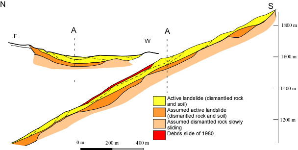
Fig. 2: Cross-section of the landslide (modified after Duti, 1984).
References:
G. Bianchetti, J-D Rouiller, S. Fracheboud (2001): The Peillettes landslide (Valais, Switzerland). European Geophys. Soc., Nice Abstract EGS XXVI General Assembly.
DUTI, (1984): Detection et utilisation des terrains instables. 140 p.
CREALP Page
Vulliet, L. (2001): Instabilité des massifs de sol. In : Schrefler, B. and Delage, P. (Eds.), Hermès Science, Paris, 66-88.