Risk analysis
Risk analysis is the final goal of all approaches dedicated to natural hazards. Eventually have to know where dangerous processes can occur (Fig. 1), what their magnitudes are and how objects and people submitted to potential natural hazards can be affected.
The cots-benefit analysis (Fig. 2) is implicit for most risk analysis. The study of natural hazards must be optimized as well as countermeasures designed to limit risks.
One of the main points is the information to the public. Better-informed and better people educated can live more easily under risk than people not educated in natural risk matter. This assertion is especially true regarding evacuation or appropriate behavior in case of earthquakes. More important is the respect of the state of the art in construction of new buildings and infrastructures in areas submitted to specific hazard (floods, rockfall, debris-flow, earthquakes, etc.), this can be carried out only if each level of a society takes into account natural hazards.
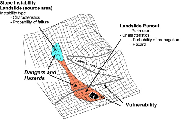
Fig. 1: Classification of elements participating to natural risk linked to landslides for landslides (modified after Jaboyedoff et al., 1999).
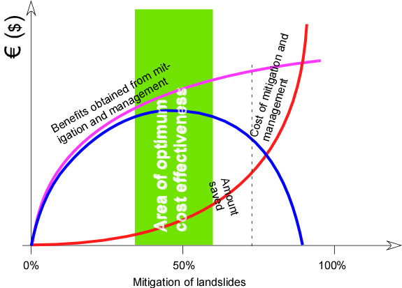
Fig. 2: Illustration of a cost benefit analysis. Here the costs of mitigation increased dramatically with degree of mitigation and the benefit reaches a plateau. The optimal result is obtained in for an intermediate value of mitigation (Modified after Nebel and Wright, 1996)
The global approach of natural risk management must lead to acceptable costs. This point must never be forgotten for scientists and engineers in the design of methodology and design of countermeasures.
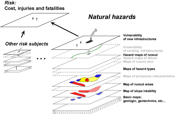
Fig. 3: Different level of knowledge that must be clearly identified for a risk analysis. The use of GIS is recommended (modified after Jaboyedoff et al., 1999).
Elements leading to risks assessment in short: Example of slope landslide
Adapted from: Multilingual glossary of rock-fall hazard and risks (Related sites: www.crealp.ch and www.risknat.org)
Danger D describes the characteristics, i.e. the intensity or magnitude of a localized existing or potential phenomenon of slope instability, with specific geometric and mechanical characteristics. The Probability of failure Pr of a landslide is that a specific volume, within a given time unit and within the considered slope break appart. Probability of propagation Pp is the probability that a portion of the landslide, with given characteristics, and located in a given portion of the slope, moves or transits across a considered area. Hazard H is the probability of occurrence in a given location and time period of a dangerous phenomenon (landslide) of a given type. Coupling Pr (frequency) and Pp (spatial ratio) the hazard is given for a point x and the danger D:
H(x,D) = Pr(D) * Pp(x,D)
Their dimension is a frequency.
Elements at risk E are population, property, economic activity, public services or environmental goods situated in a location exposed to danger. The Worth of element at risk W is the economic value, or number of units of each element at risk situated in a given location:
W = W(E)
Vulnerability V is the degree of loss of one or more elements at risk resulting from a dangerous phenomenon with a given intensity:
V = V(D, E)
It varies from 0% (no loss) to 100% (total loss).
Potential worth of loss Wl
Potential loss caused by an event with a given intensity.
Wl = Wl(D;E) = W(E) * V(D;E)
It is expressed either in number of exposed unites or in economic value. Specific risk Rs is the expected degree of loss within a given period of time of an element at risk that can be caused by a dangerous phenomenon with a given intensity:
Rs = Rs(D;E) = H(D) * V(D;E)
It is expressed as an annual probability. Total risk Rt is the expected losses of lives, persons injured, property damaged, and economic activity disrupted due to a particular dangerous phenomenon:
Rt = Rt (D;E) = H(I) * V(D;E) * W(E)
Rt = Rs(D;E) * W(E)
Rt = H(D) * Wl(D;E)
It is expressed either in terms of number of exposed units, or in financial terms.
References
- Canuti, P., and N. Casagli, Considerazioni sulla valutazione del rischio di frana, fenopmeni franosi e centri abitati, Atti del congresso di Bologna del 27 maggio 1994. Pubblicazione n°846, 1994.
- CFGI (Comité Français de Géologie de l’Ingénieur), Caractérisation et cartographie de l’aléa dû aux mouvements de terrain. Collection “Environnement – Les risques naturels”, pp. 91, Laboratoire Central des Ponts et Chaussées, 2000.
- Cruden, D. M., and D. J. Varnes, Landslide types and processes, in A. K. Turner and R. L. Schuster, Landslides, Investigation and Mitigation, vol. Special Report 247, edited by, pp. 36-75, National Academy Press, Washington, D.C., 1996.
- Einstein, H. H., Landslide risk – Systematic approaches to assessment management, in D. M. Cruden and R. F. Fell, Landslide assessement, pp. 25-50, A.A. Balkema, Roterdam, 1997.
- IDNDR, Glossary: international agreed glossary of basics terms related to Disaster Management, pp. 83, DHA-Geneva, 1992.
- Jaboyedoff M., Baillifard F., Hantz, D., Heindenreich, B. et Mazzocolla D.:Terminologie. In, Prévention des mouvements de versants et des instabilités de falaises. Confrontation des méthodes d’étude des éboulements dans l’arc alpin. Programme Interreg IIC – « Falaises ». Méditerranée occidentale et Alpes latines. 48-57. In Confrontation des méthodes d’étude des éboulements dans l’arc alpin. Programme Interreg IIC – « Falaises ». Méditerranée occidentale et Alpes latines. 70-83. 2001.
- Nebel, B.J. and Wright, R.T., Environmental Science. Fifth ed. Prentice Hall. 698 p. 1996.
- PPR, Plans de Prévention des Risques naturels, risques de mouvements de terrain. Guide méthodologique, pp. 71, Ministère de l’aménagement du territoire et de l’environnement, ministère de l’équipement, du logement et des transports. La documentation française, 1999.
- UNESCO, A suggested method for reporting a landslide. The International Geotechnical Societies’ UNESCO Working Party on World Landslide Inventory, Bulletin de l’Association Internationale de Géologie de l’Ingénieur, 41, 5-12, 1990.