Meta

  • Log in
  • Entries RSS
  • Comments RSS
  • WordPress.org
Toggle SlidingBar Area
Quanterra Quanterra
  • Home
  • About
    • News
    • Approach
    • Employees
    • Foundation council
    • Statutes
    • Media
    • Contact form
  • Topics
    • Erosion & Natural Hazards
    • Risk
    • Earth Science Math
    • Alpine Geology
    • Mineralogy
  • Activity
    • Projects
    • Education
  • Publications
  • Resources
    • Software
    • Data and other
    • Photo gallery

Projects

geocover
Permalink
Gallery

GeoCover

Projects

GeoCover

Projects

quanterra 2016-02-11T08:44:53+00:00

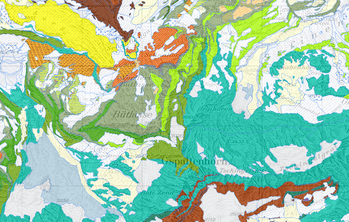
GeoCover - Geological vector datasets2011-2016Several people are in charge of implementing the Project GeoCover of the full digital coverage of Switzerland by 1:25,000 geological maps with Swisstopo.Data sets based on compilations are gradually updated with data from the Geological Atlas. The geological vector datasets offer a state-of-the-art foundation for creating further geothematic datasets, e.g. in the domain [...]

Learn More
Logo_Mountain-Risks
Permalink
Gallery

Mountain Risks

Projects

Mountain Risks

Projects

quanterra 2016-02-11T08:04:45+00:00

Mountain Risks: from prediction to management and governance2007-2011Mountain Risks is a Marie Curie Research Training Network in the 6th Framework Program of the European Commission. Its focus is research and training in all aspects of mountains hazards and risks assessment and management. This European network intends to develop an advanced understanding of how mountain hydro-geomorphological [...]

Learn More
coltop_3d_fr-2
Permalink
Gallery

Design of Coltop

Projects

Design of Coltop

Projects

quanterra 2016-02-11T08:49:25+00:00

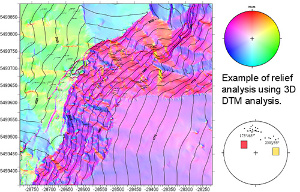
Design of a pseudo-3D topographic analysis computer program: COLTOP2003The design of a program of topographic analysis based on digital elevation model (DTM) is presented here. This software COLTOP-3D can be used to analyze the structures, especially faults, shaping the morphology. Maps as well as stereonets displaying colors depending on the orientation will be implemented. Histograms [...]

Learn More

Address

Quanterra
Dr. M. Jaboyedoff
Ch. Tour-Grise 28
CH-1007 Lausanne

Contact

Quanterra,
Dr. M. Jaboyedoff
Mobile: +41 79 752 35 15
Email: info@quanterra.ch

Quanterra in brief

International Independent Center of Climate Change Impact on Natural Risk Analysis in Mountainous Areas

Other information

Why in english
Legal form (art. 80)

Copyright 2016 Quanterra | All Rights Reserved